9.2 Weather Hazards
Weather Hazards
Well,
this has been a great journey, I have learned a lot. I appreciate all the feedback
that I have received through the course. Our last blog post is about hazardous
weather conditions that present the greatest risk to aviation operations. So,
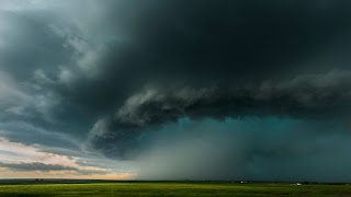
today we are going to discuss the Cumulonimbus cloud, commonly known as thunderstorm clouds.
These clouds have a heavy, dense structure with a dark gray/gloomy, tall appearance. Ranging from 2000 ft (where the angry base resides) to 40,000 ft (where their strong anvil-shaped tops are). They are high on the risk factor because their guest list is filled with popularity, its associated are lighting, thunder, precipitation, and even tornadoes.
Their formation can be broken down
into parts, the lowest mainly composed of water drops and is typically warmest.
As the middle area contains water drops and ice crystals, they also include the
most movement of air through up-drafts and down-drafts. The top portion contains only ice crystals due to the temperature in this section. These clouds can bring
surface gusts differing in strength and direction directly affecting the
take-off and landings of aircraft. Ahrens mentions that these violent
up/down-drafts can exceed 70 knots, just over 80 MPH. (2007) If you happen to
be flying in the higher levels of the cloud you could also experience flight
icing, other areas have a higher risk of being struck by lightning also. 70
percent of lightning-strike events occur during precipitation however, the
probability of a lightning strike decreases significantly above 20,000 ft. (Sweers,
2012) Though at that point you’ll probably get pummeled by another condition like
ice.
Ahrens,
C. Donald. (2007). Meteorology today: an introduction to weather, climate, and
the environment. Belmont, CA: Thomson/Brooks/Cole
Sweers,
G. (2012). Lightning Strikes: Protection, Inspection, and Repair.
https://www.boeing.com/commercial/aeromagazine/articles/2012_q4/4/


Comments
Post a Comment